2006: The Year of Mapping Dangerously
Travel Blog • Ben Keene • 12.21.06 | 1:00 PM ET
‘Tis the season to look back on the year that has passed and make lists, and those of us in the maps business are no less backward looking than others. Borders shift, populations grow or shrink, and place names are altered. The pace of change can be mind-numbing. So I thought I’d compile my own short—and consequently incomplete—list of some of the most noteworthy geographical developments of the last 12 months.
During the summer in the United States, President Bush designated roughly 140,000 square miles of Pacific reefs and atolls as a national monument. This act makes the Northwest Hawaiian Islands, which cover more surface area than 46 of the 50 states, the single largest protected marine sanctuary on Earth, just edging out the 133,000 square miles of Australia’s Great Barrier Reef Marine Park.
Europe helped make the year a particularly eventful one for geographers this June by welcoming the nation of Montenegro (formerly the Republic of Serbia and Montenegro), which replaces East Timor as the world’s newest country. Prior to 2003, and following many years of unrest, both Serbia and Montenegro had been a part of Yugoslavia.
Elsewhere on the continent, New Forest National Park, the largest area of lowland heath in Britain, appeared on the map as England’s first park to be created in the last 50 years. And across the North Sea, the Danish government decided to reorganize its 14 counties into five larger regions, a major reform that will go into effect on Jan. 1, 2007.
Drifting farther south, the conflict in Darfur continued to smolder in 2006 and has given Sudan the distinction of having more displaced people than any other country on the planet: roughly 6 million to date. The loss of life has been estimated in the hundreds of thousands with a similar number of refugees fleeing to neighboring Chad. Until the African Union and the larger international community address this crisis, the deadly toll of this genocide can only rise.
In a more encouraging development on the continent, however, the landlocked nation of Lesotho unveiled a new flag in October, 40 years after gaining independence from the United Kingdom. Its three colors representing rain, peace and prosperity remain unchanged, but a black hat symbolizing the country’s indigenous people replaces an image of a traditional African shield that appeared as an emblem on the previous flag.
Changes to place names and their transcriptions (which help keep mapmakers employed) occurred in several locations around the globe, replacing once-familiar labels with new words and spellings that will require additional memorization from geography bee contestants in the months ahead. South Korea officially revised its Romanization of the language in part to preserve phonetic differences, while in India, Bangalore elected to follow in the footsteps of other cities throughout the Deccan Plateau by dropping its colonial moniker in favor of Bengaluru.
China completed the highest railway in the world ahead of schedule, enabling travelers to journey from Beijing to Lhasa by train in less than three days. Climbing to an elevation of 16,640 feet, the route carries riders in oxygenated cars across the enormous and inhospitable Tibetan plateau. Following on the heels of the completion of the Trans-Siberian highway last year, this achievement continues to make travel in Asia easier.
As urban populations in Latin America, Africa and Asia continue to rapidly expand, governments must develop new infrastructure to meet the needs of citizens sharing crowded cityscapes. Taiwan, for example, where nearly 23 million inhabitants occupy a mountainous island, opened Asia’s longest road tunnel this year as a way to more efficiently move goods and people to and from the growing metropolis of Taipei.
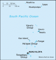
But people aren’t doing all of the building. Even as destructive tsunamis swept across the Indian Ocean in late 2004, reshaping coastlines and, in the case of the tiny Republic of Maldives, removing some islands from the map altogether, new landmasses appear on other parts of the globe. The Kingdom of Tonga (whose map is pictured here), another archipelago in the South West Pacific, is in the process of adding a new island near Home Reef, roughly 160 miles from Nuku’alofa, the capital city.
And finally, one last bit of sobering news. Updated cartography of the poles confirms what climate scientists have been trying to tell us for years: The ice caps are shrinking. A consensus about the best way to curb the carbon emissions that are at least partially responsible for this has not been reached, but there is little doubt that consequences such rising sea levels loom in the foreseeable future. So while a reduction in the summer sea ice in the Arctic could offer benefits like shorter shipping routes, it also promises disadvantages that we should be thinking about, too—and that means changing more than just our atlases.
—.(JavaScript must be enabled to view this email address) is the editor of the Oxford Atlas of the World.