Mapping the World: Is Accuracy Possible?
Travel Blog • Michael Yessis • 10.17.06 | 8:03 AM ET
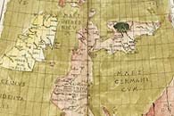
Probably not, according to this BBC story. Map-makers are in a constant battle to juggle scale, distance and the curvature of the earth, not to mention often having to shrink Africa down so it can fit in the frame. The 1477 Ptolemy atlas that was sold for $3.9 million at Sotheby(tm)s in London last week shows where we’ve come from—that map has “England butting the Bay of Biscay and Scotland floating in the German Sea”—and where we’re going.
In the race for reality, maps have come a long way since then. But with internet tools like Google Earth, cartographers feel they have taken a major step forward in showing a real picture.
On a world scale, the pictures on Google Earth, and programs like it, look accurate. The view is less skewed than with some other projections, such as cartographic models used to set out the world.
So will it ever be possible to produce a truly representative map? It can be done on a globe, says Steve Chilton, chair of the Society of Cartographers. But it would “have to be massive.”