The Deceptive Magic of Travel Photography
Spud Hilton: If you've seen it in a guidebook, that elusive, perfect view must really exist. Right?
04.06.10 | 1:17 PM ET
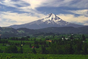 Photo by
 I looked up to see Mount Hood and it wasn’t there. Gone. I looked down again at the photograph in the guidebook and there it was, Oregon’s most iconic feature, rising majestically over the hamlet of Hood River.
I looked up again, and it was gone. My only consolation was that the great explorers Lewis and Clark faced a similar problem, among others, on the Columbia River. They ran uncharted Class 5 rapids (the founders of extreme whitewater canoeing), faced potentially hostile tribes daily and were forced to buy dogs from local villages at an alarming rate. (One of the Corps of Discovery’s discoveries was that they preferred the taste of house pet over fresh salmon.)
And they had trouble finding Mount Hood.
But for all their obstacles, they had an advantage over me—they weren’t using a travel photograph to locate Oregon’s highest peak. We’ve all been there, lured to faraway lands by impossibly beautiful scenes in a magazine that, it turned out, were impossible to see—without the aid of a well-equipped Nikon, at least. A few years ago, I opened a copy of Islands magazine, only to stop on an ad with the dream tropical scene: A blessedly empty beach with powdery white sand, skinny palm trunks weighted with coconuts and waxy fronds, and a placid sea that you can tell is warm just by looking at it, reflecting improbable shades of blue and green. But the advertisement touted Playa del Carmen, Mexico, and I knew immediately that some photographer had worked pretty hard to find an angle that could make a touristy, dusty, noisy city of 49,000 people seem like a secluded island paradise. It’s like shooting a photo of Marilyn Manson to look like Marilyn Monroe.
Photography has that magic. Wide-angle shots make castles look expansive, filters make Caribbean skies bluer and water greener, and long lenses compress great distances. My downfall was the last of these: In the Columbia River Gorge guidebook photo, the town of Hood River appears to be a Coho salmon’s leap from Mount Hood. It looks as if you can ski down the mountain’s northern slope right onto Fourth and Oak streets downtown, shake off the powder and order hot chocolate at Anz Cafe.
But standing on a dock over the banks of the Columbia, I could see the town, its quiet streets lined with gift shops, brew pubs and sporting goods stores, but not the 11,000-foot mountain behind it.
To be fair, much of Hood River is on a hillside. Maybe I was already on the mountain and just couldn’t see the top. Having only one way to be sure, I re-laced my boots and started up through town, determined to find a clear view of the mountain. I had tried first to walk across the Hood River Bridge to White Salmon on the Washington side, mostly to get the view from there, but was stopped by a “No pedestrians” sign posted by the Oregon Department of Transportation. I hiked up Oak Street, which had been a stretch of the Columbia River Highway (the first paved public road in the Northwest), past the downtown businesses and the cottages and modest Victorians with their meticulously casual yards and lawn placards stating “Vote Yes for Schools.” I felt like knocking on doors and asking locals what it’s like to live in the shadow of Mount Hood. Do they fear avalanches? Do snowboarders tromp through their gardenias?
At 13th Street, I spotted a snowy peak to the north that I was pretty sure was Mount Adams, jutting up between the green hills on the Washington side of the river. Just to be on the safe side, I pulled out the cell phone and called my wife in San Francisco.
“Honey, could you look up Hood River on the Internet? Got it? Which way is Mount Hood?”
(It turns out Internet map programs don’t usually show geologic features. You can locate a 20-yard alley in downtown Portland, but you can’t get it to show the location of the tallest, most iconic feature in this corner of the Pacific Northwest. She did, however, confirm that Hood River is 1,372 miles from Flagstaff, Arizona.)
Finding Mount Hood was a priority for the Corps of Discovery, too. During their epic voyage down the Columbia in fall 1805, Lewis and Clark knew that the giant stratovolcano was the first mapped feature they were likely to see since leaving Montana, and a sure sign that the Pacific was reachable. (Believe it or not, there are the equivalent of barroom brawls among historians over when Lewis and Clark actually saw the mountain—and which one saw it first. The Washington State Historical Society Web site talks about a recent study on the topic “using an interdisciplinary combination of textual analysis, computer modeling, and field observation.” Um, OK.)
Based on the angle of the hill, the position of the sun and a flipped coin, I turned south up 13th Street, a major byway between north and south Hood River. I trudged past tree-lined streets, a couple of schools and a drive- thru espresso shop, craning my neck every so often to attempt a glimpse of the mountain. Just past the hospital, I reached the crest, only to find trees and homes blocking any peek at the peak. The trek had turned into my personal Bitterroot Mountains, the range that Meriwether Lewis climbed expecting to see the Pacific, only to find row after row of jagged, snow-topped peaks filling the horizon.
Three blocks later, I saw it—a vertical slice of the snowy icon, framed by an insurance agency sign and Fishers’ Inn, a shuttered country restaurant.
I had expected a wall of mountain filling my view. I got a distant, albeit beautiful, peak on the horizon, about 20 miles away. I blocked my view of Mount Hood by holding up a can of Diet Coke at arm’s length. Claims I’d read that Hood River is the “Gateway to Mount Hood” made about as much sense as Antioch claiming to be the “Gateway to San Francisco.”
The photo from the guidebook had, quite obviously, been taken from a custom-made helicopter by a team of specialists in harnesses hanging from trapeze bars suspended by a web of high-tech pulleys, using something akin to the Hubble telescope.
I finally looked at the photograph credit in the guidebook, hoping to find the name and address of someone I could beat with a tire iron. In tiny letters, it said, “Photo by Oregon Dept. of Transportation.”
Aha.
 del.icio.us
 Digg
Digg Facebook
 Furl
Furl Ma.gnolia
 Mixx
Mixx Reddit
 StumbleUpon
 Yahoo! Buzz
Elizabeth 04.06.10 | 3:44 PM ET
I hope the Oregon Department of Transportation gets a link to/hardy copy of this article.
TKGO 04.07.10 | 2:37 AM ET
Photography while traveling really is tricky. I have found it sometimes renders views better than they ever could have been in person, and other times the lens hardly captures what I saw and felt. I had the latter experience recently when I returned from Cuba and skimmed though my 500+ photos. I thought I had done a phenomenal job documenting my trip, but when I looked at it all objectively, it just didn’t add up. Still, I would rather have those tangible photos than just ones in my mind.
-Karina
(Some of the photos are here: http://taraandkarinagoout.com/2010/03/31/back-from-cuba/)
Travel-Writers-Exchange.com 04.07.10 | 8:52 AM ET
That’s the power of photography. Sometimes it’s too powerful because the pictures can be more interesting or breathtaking than the “real deal.” Plus, to get a perfect shot you may have to become a “stunt person or acrobat” for the day.
Levinson Axelrod 04.07.10 | 1:17 PM ET
Very inspirational post and story. Great knowing you’ve found the magic in photography.
pam 04.07.10 | 10:25 PM ET
I shot photos for a guide book a few years back and found the guidelines fairly comical. Photos were not to be prosaic, they were not to show people eating, they were to look natural, not touristy, which was odd as they were of tourist destinations. This was a little easier in British Columbia, but when I shot pics in Hawaii, well, they all looked prosaic and touristy, though rarely did they show people eating.
Thoroughly enjoying all the Spud Hilton on World Hum lately, thanks.
gary grilli 04.08.10 | 2:13 AM ET
Spud,
I call it the Sunset Magazine syndrome. Shit can the guidebook and remember that
the best pictures are taken with the mind’s eye.
Mango Dude
Larry J. Clark 04.08.10 | 6:06 AM ET
When we look at one of “those” travel photos, we see the result, but not the work.
Last weekend I shot a picture. I had an idea where I wanted to shoot, and I scouted the location on Google Maps. Then I went to a NOAA web site that gave me the azimuth of the rising sun for Saturday and Sunday. That site also had a Google Maps interface, so I could determine where on the banks of the Potomac I needed to be. I got up (way too early for my taste) on Saturday morning, drove to a parking area and humped my tripod and camera bag down the bike path to the location. Still in darkness, I could barely see my target across the river, but could confirm my location and shooting direction with a compass sighting. I set up the tripod, made the camera settings, framing, etc., and eventually took the shots.
Then I went home. Simple.
This was no great piece of art…Just a utility shot that I needed for a sequence.
Visiting Italy 04.13.10 | 8:37 AM ET
Great post. Photography is so powerful in the way that it can bend reality into something completely different. It’s easy to assume that a photograph must be a literal representation, but so often it’s not.
Dave 04.22.10 | 8:51 AM ET
Great post. I worked at Mount Hood for 6 months way back when, and we could seldom see it from Hood River where i stayed due to the clouds….