Playing With Maps: New Ways to See the World
Travel Blog • Jim Benning • 10.02.08 | 2:35 PM ET
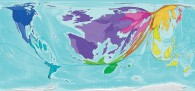
The Telegraph has published an eye-opening series of world maps that re-work the size of nations to reflect various demographic and statistical truths about them. My favorite? This one (pictured, and much bigger here), in which the “size of each country indicates the proportion of international tourist trips made there.” Yes, Western Europe is huge. This one, in which India is giant, reflects rail travel. (Via Andrew Sullivan)
 del.icio.us
 Digg
Digg Facebook
 Furl
Furl Ma.gnolia
 Mixx
Mixx Reddit
 StumbleUpon
 Yahoo! Buzz
Jim Benning is the editor and co-founder of World Hum.
Kelsey 10.03.08 | 9:43 AM ET
Another great place to find maps like these is http://www.worldmapper.org.
My favorite map is this one depicting where our clothes come from: http://www.worldmapper.org/display.php?selected=83#