The First Travel Photo and the Future of Photography
Jeff Pflueger: Jeff Pflueger on the intersection of geography and photography
01.28.10 | 11:15 AM ET
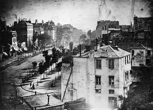 Boulevard du Temple by Daguerre (Wikimedia Commons)
In 1838, Louis Jacques Mandé Daguerre made an eight-minute exposure of a busy city street. His resulting “Daguerreotype” photograph only captured the motionless: buildings, a tree-lined street and a single man having his shoes polished. Everything moving blurred into invisibility. Some have described the image as the first photograph of a person. I think it’s more than that. The man was captured candidly in a daily activity and the scene around him communicates volumes about the location. The image conveys a sense of place strong enough to make it, arguably, the world’s first travel photo.
As a travel photo, though, it lacked an important piece of information. Where exactly is this street?
So, Daguerre helped us out and titled the photograph, “Boulevard du Temple, Paris.”
This extra information is a version of what we today call metadata. Metadata literally means information about information. Digital cameras pack all kinds of metadata invisibly into our images without us even noticing: the shutter speed, aperture, date, time, camera make and even serial number.
But while Daguerre chose location as an important piece of metadata when he decided on the title, today’s cameras by and large exclude location. Granted, additional hardware is required to track one’s location, but if my cell phone can automatically embed my images with location (this is called geotagging), why won’t most modern cameras?
We will see this change very quickly, and it is going to cause another small revolution in photography. But even today, as photography and geography increasingly intersect, images can be related to place, and to each other, in ways that would have astounded Daguerre.
Recently I was photographing the mountains of the Alaska Range from the air for the National Park Service. Bundled in a down parka and mitts, with an oxygen mask strapped to my face, I stuck the lens out an open window and fired off images of remote peaks and glaciers, including the tallest mountain in North America. I did this all from an unpressurized turboprop Cessna.
Removing my mask to photograph, I soon learned why flight attendants lecture about putting an oxygen mask on ourselves first; lack of oxygen creates a more sinister inebriation and greater denial than a drunken night in Tijuana. You’ll be blissfully blacking out from too few O’s while feeling just fine.
I was anticipating hundreds of images over a huge area from each flight, and I knew that I might be a bit “altered” from the thin air. So, to help with organization and identification, I brought along a GPS unit, and later geotagged the images using software.
According to the metadata, there are pictures I took at 22,838 feet while looking down at the highest point in North America. I remember taking them only in an anaerobic dream.
Once images contain latitude and longitude, they can be presented in entirely new ways. For example, the images of Denali I made can be presented on a Google map. Browsing through the images now becomes a geographical exploration rather than a slideshow.
But putting geotagged photos on a map is just the beginning. Microsoft has developed a tool called Photosynth to build three dimensional models from several images made from different angles. For example, a “synth” has been built of the Notre Dame Cathedral from images found on Flickr. Another synth was built of Obama’s inauguration from hundreds (thousands?) of photos taken from many different photographers. Photosynth doesn’t read the metadata in each image for location, but rather finds common features in the images themselves to compute the locations of each of the cameras.
While the concept of crowd sourcing images into a navigable 3-D model is mind blowing, the interface is a bit clumsy, and Microsoft prompts you to download some proprietary software to view a Photosynth. Still, my photosynth of Denali is at least interesting once you learn your way around.
Daguerre knew a good idea when he saw one. After teaming up with Joseph Niépce, the man who made the first photograph, Daguerre developed his own process for creating photographs, the Daguerreotype, and changed the world.
The ways in which geography and photography are intersecting today are limitless. As travel photographers, especially, we need to be part of this advancing area and start pushing the envelope.![]()
 del.icio.us
 Digg
Digg Facebook
 Furl
Furl Ma.gnolia
 Mixx
Mixx Reddit
 StumbleUpon
 Yahoo! Buzz
Jeff Pflueger is a San Francisco Bay Area based photographer and web geek. His adventure travel photographs involving all kinds of outdoor lunacy have been published in National Geographic Adventure, the New York Times, Men's Journal, Sunset and other publications.
Sean O' 01.28.10 | 1:44 PM ET
Super article!
Marilyn Terrell 01.29.10 | 1:20 AM ET
Great article, Jeff! National Geographic has completed a bunch of world wonders in Photosynth, and is looking for crowd sourcing to build lots more: http://ngm.nationalgeographic.com/photosynth/synth
greg 01.29.10 | 8:14 AM ET
Travel photo! Hardly. Mr Daguerre exposed the plate from his apartment window in Paris. And the name is Louis Daguerre, not Jacques which is a middle name. Otherwise good article.
Robert Reid 01.29.10 | 11:31 AM ET
Wonderful photo and article—I always enjoy looking at details of 100-year-old photos (or older) and seeing what people were captured in a moment and never knew it. Eerie in a way. That shoe shine is classic.
Do agree it’s not really a travel photo, but worth talking about still.
Queretaro 01.29.10 | 1:08 PM ET
Great read. What amazes me is the 8 minute exposure required to get the photo. Nowadays if I have to wait more than 30 seconds on my night Photos on my SLR I get impatient. But then again, in a few decades people may wonder how we could stand only being able to take 3 photos a second.
Jeff Pflueger 01.29.10 | 1:28 PM ET
Good comments! The photo is clearly from Daguerre’s own country - indeed, HE was not traveling when he made the image. In my opinion, a photographer needn’t travel to make a travel photograph. A travel photo is a travel photo when it takes the viewer on a short imaginary travel.
Daguerre’s image does that for me.
By the way, check out Greg’s (commenter above) Daguerrotype gallery.
Given the credentials, while Daguerre is frequently referred to as “Jacques”, we should clearly take Greg’s advice and use the full name: Louis Jacques Mandé Daguerre.
James Kelly 01.30.10 | 11:33 AM ET
Great article! I agree that the photographer doesn’t have to travel, but propel the viewer on an imaginary excursion, for the image to be a travel photo. And Daguerre was traveling in a new media, which qualifies. This is one of my favorite Daguerreotypes, but Widapedia suggests that this image was made over more than ten minutes. Don’t mean to quibble, though. And I learned a great deal about metadata, and started my own “travels” on the web to learn more. Thanks!
Color Experts International 03.21.10 | 5:27 AM ET
Thanks for the nice post of travel photography….
I think travel photography is changed from the past few decades…