Mapped: The Arctic Becomes an ‘Oceanic Crossroads’
Travel Blog • Michael Yessis • 10.21.08 | 1:33 PM ET
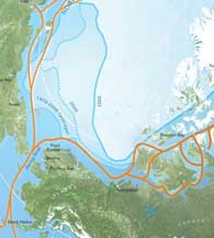 Thumbnail of map via The Atlantic.
 The beautifully redesigned Atlantic features a map of the Arctic, which marks the paths of the now-viable Northwest Passage and outlines the global significance of the shrinking polar ice cap. “The opening of a new waterway between the Atlantic and Pacific oceans is akin in historic significance to the opening of the Suez Canal, in 1869, or its Panamanian cousin, in 1914.” writes Scott Borgerson. “With this sea change will come the rise and fall of international seaports, newfound access to nearly a quarter of the world’s remaining undiscovered oil and gas reserves, and a recalibration of geo-strategic power.”
Borgerson adds more detail in this slideshow:
 del.icio.us
 Digg
Digg Facebook
 Furl
Furl Ma.gnolia
 Mixx
Mixx Reddit
 StumbleUpon
 Yahoo! Buzz
Michael Yessis is the cofounder and coeditor-in-chief of World Hum.