800-Year-Old Roman Empire Courier Map Goes on Display. Briefly.
Travel Blog • Michael Yessis • 11.27.07 | 9:11 AM ET
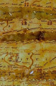
The Tabula Peutingeriana (excerpt pictured), an 800-year-old copy of a chart used by the Roman Empire’s courier service, was pulled from the archives of Austria’s National Library yesterday as part of a celebration of its new “Memory of the World” status by UNESCO.
It was a rare display as too much exposure to light can swiftly damage the map. The 7-meter-long scroll, which outlines routes stretching as far as Spain, Britain, North Africa and China, is believed to have been copied in Germany in the 12th century.
 del.icio.us
 Digg
Digg Facebook
 Furl
Furl Ma.gnolia
 Mixx
Mixx Reddit
 StumbleUpon
 Yahoo! Buzz
Michael Yessis is the cofounder and coeditor-in-chief of World Hum.
Ben 11.28.07 | 11:30 AM ET
An interesting thing the news doesn’t mention about this map: notice that it’s oriented East-West (reflecting the importance of the Mediterranean and its surrounding societies) rather than North-South, a more modern convention.
Michael Yessis 11.28.07 | 11:53 AM ET
Interesting, Ben. Anyone who follows the top link above can see the map in full—something I couldn’t really fit into the blog post.