Scientists Unveil High-Def Map of Antarctica
Travel Blog • Jim Benning • 11.30.07 | 12:13 PM ET
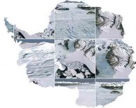 Photo courtesy of NASA.
Antarctica fans, and perhaps a few cruise ship captains, might want to check this out. U.S. and British researchers unveiled a new high-definition view of Antarctica this week, piecing together more than 1,000 Landsat satellite images and, according to NASA, creating “the most geographically accurate, true-color, high-resolution views of Antarctica possible.” Thanks for the tip, Ben.
 del.icio.us
 Digg
Digg Facebook
 Furl
Furl Ma.gnolia
 Mixx
Mixx Reddit
 StumbleUpon
 Yahoo! Buzz
Jim Benning is the editor and co-founder of World Hum.
Ben 12.03.07 | 6:07 PM ET
Always happy to be the source of a geo-news tip or three…